Rottingdean
With a postcard historic centre, the coastal village of Rottingdean is located to the east of Brighton & Hove with approximately 2,500 inhabitants. Historically a farming community, from the late 18th century, Rottingdean began to attract leisured visitors wanting an alternative to Brighton. Of note in the late 19th century, the painter Sir Edward Burne-Jones and his nephew Rudyard Kipling, made it their home.
Still standing is Kipling’s old house adjacent to Kipling Gardens, with the former house of the painter Sir William Nicholson currently open to the public as a library and museum.
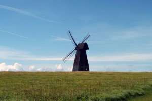
Rottingdean is also notable for the black wooden windmill (pictured) on the hill on its western side. The hill is a local nature reserve. It was also well known for sport, having the earliest cricket club on record founded in 1758. Also of interest is the 13th-century church of St Margaret which features stained glass by Edward Burne-Jones, whose ashes are buried in the churchyard.
Most histories of Rottingdean mention that its inhabitants were involved in smuggling, mainly in the 18th century. Nowadays, Rottingdean is well served with Primary and Secondary schools and is just 4 miles from the centre of Brighton with superb bus links both to Brighton and to Eastbourne.

Brighton
Located on the south coast, Brighton together with its immediate neighbour Hove forms became the City of Brighton and Hove as part of millenium celebrations and is one of the most famous seaside resorts in the UK. It was originally named Brighthelmstone in the Domesday Book (1086) and in June 1514, Brighthelmstone was burnt to the ground by French raiders during a war between England and France. Only part of St. Nicholas Church and the street pattern of what is now The Lanes survived the attack. Nowadays Brighton is a popular tourist resort with numerous hotels, restaurants and entertainment facilities and the modern city has two universities and many English language schools.
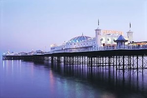
The Pavillion was built during the 1740s and 1750s and enlarged for the Prince Regent (later King George IV) after his first visit in 1783. Between 1815 and 1822 the designer John Nash redesigned the palace, and it is the work of Nash which can be seen today. The Victorian era saw the building of many of the other famous landmarks including in 1864 The Grand Hotel, in 1866 The West Pier and in 1899 The Palace Pier (now called just Brighton Pier).

Woodingdean
An eastern suburb of the city of Brighton and Hove although separated from the main part of the city by downland and the Brighton Racecourse. Woodingdean was developed after the First World War in the northern part of the parish of Rottingdean and consisted of plots of land on the South Downs which had formerly been used for sheep-farming. These were sold by developers (often but not exclusively to returning soldiers) and most were originally smallholdings, e.g. poultry farms. At a former school in Warren Road, whose site is now a hospital, is the deepest hand-dug well in the world. North Woodingdean is the highest part of Brighton and Hove above sea-level.
The development of the present residential area very much mirrors that of neighbouring Ovingdean and in 1928, both became part of Brighton County Borough. The area was extensively developed during the 1950′s and 60′s when most of the roads in the Southern end of the village were built. The area has a population in excess of 10,000 but despite its size still manages to maintain its village atmosphere. Woodingdean has two primary schools.
Newhaven
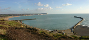
Lying at the mouth of the River Ouse on the Sussex Coast is the town of Newhaven best known in recent times for it’s car ferry port for services across the English Channel to Dieppe in Normandy. The port handles industrial traffic and there is also a small marina. The huge Newhaven Fort, built on Castle Hill in the 1860s, is only the last of several built here since Bronze Age times. It is now a visitor attraction. Newhaven used to be named Meeching until the 16th century when a great storm diverted the course of the Sussex Ouse so forming a New Haven.
To the east of Newhaven is the derelict village of Tide Mills which is the remains of workers’ cottages, a tide mill, and a large saline lagoon which was the storage pond for high water to power the mill on the outgoing tide.

Saltdean
Probably named after the salty sea-spray that covered the grass after storms, Saltdean was, for centuries, a large area of Downland with only a few isolated farm buildings and cottages. Lower Bannings Farmhouse, at Bannings Vale, is the oldest building still standing and dates from the mid-18th Century.
The history of the present housing estate began in 1916 when the land was acquired by speculator Charles Neville. In 1924, he established the Saltdean Estate Company in an office by the coastguard cottages. His purchase of the Saltdean area was completed in 1925. Miles of new roads were laid – surfaced with chalk quarried from a pit in Greenbank Avenue – and a small railway was built to convey the materials along the Vale. The Estate Company was taken over by Homemakers Ltd and development of the area continued after the war until the Seventies. The Lido park, known also as the Oval because of its shape, covers 18 acres. There is now a bowling green and pavilion.
At the southern end of the park, stands the Saltdean Lido, opened by the Estate Company in 1937. The main building was designed by Richard Jones and, in July 1987, it was listed. The pool itself measures 140ft x 66ft and can accommodate 500 bathers. During the Second World War, the pool was used as a water tank by the National Fire Service College which was based at the Ocean Hotel. It is only five miles to the centre of Brighton with superb bus links. Saltdean has its own Primary school and various play groups.
Brighton Marina
A large, artificial marina, Brighton Marina Village was constructed between 1971 and 1979 and covers an area of approximately 127 acres. The land within the marina has been developed in several stages and now accommodates a large supermarket as well as boutique shops, a number of restaurants and bars, a hotel, a bowling alley, a multiplex cinema, a health club, a casino, and a multi-storey car-park built over the cinema. There are also several developments of flats and mooring facilities for the boats and their users, ranging from boat sales and service companies through to a launderette at the mooring level. From time to time there have been summer-season passenger services to Fécamp in France using small catamaran ferries.
Peacehaven
Peacehaven has only existed as a settlement since 1916 after its founder, Charles Neville had purchased land in the parish of Piddinghoe he then set up a company to develop the site. He advertised it by setting up a competition to name the development for which 80,000 entries were received. The winning name being chosen as New Anzac-on-Sea which lasted less than a year. The development was renamed Peacehaven. By 1924 there were 3000 people living in Peacehaven.
The town, apart from the newer development to the west named Telscombe Cliffs, still retains its original shape: rectangular plots of land on both sides of the main road. Original houses were often very temporary affairs (some were old railway carriages). Peacehaven eventually grew to be larger in area than Lewes, the county town and administrative headquarters of the region.
Although Peacehaven has grown considerably in recent years it retains its special character. An obelisk denotes the fact that the town stands on the Greenwich Meridian. The meridian line used to denote zero degrees longitude and the universal standard for calculating time was plotted from London’s Greenwich Observatory in 1894. It passes through Lewes before leaving the mainland at Peacehaven Cliffs. There are four schools in Peacehaven.
Ovingdean
Formerly an agricultural village, Ovingdean became a borough of Brighton in 1928, and now forms part of the city of Brighton and Hove with a population of about 1200. Open downland is on either side, on which may be found a golf course and Brighton racecourse as well as some residual farmland.
The name, which is Old English for ‘the valley of people associated with a man called ?fa’, shows that the village has existed since Anglo-Saxon times. The historic village is a conservation area, it’s focus is the eleventh-century church of St Wulfran. Many homes in the conservation area are converted farm buildings, and the most prominent houses are Ovingdean Grange and Ovingdean Hall. The Hall is a gentry mansion which now serves as a school for deaf and hearing-impaired children. Just outside the historic boundary of Ovingdean, and actually in historic Rottingdean, is Ian Fraser House, better known as St Dunstan’s, a famous residential and rehabilitation centre for blind ex-servicemen.
It is four miles to the centre of Brighton and a short walk to Rottingdean Village.
Roedean
Roedean Gap is a slight dip in the cliffs between Black Rock and Ovingdean Gap, and has been known as such since at least 1724. Roedean Farm once stood on the cliff top until in the 1930’s Marine Drive was constructed. There was also a windmill at Roedean from around 1750 to about 1790, and the old mill-house was amongst the buildings cleared for the road construction.
Roedean School is the independent girls’ school founded in 1885 by Penelope, Millicent, and Dorothy Lawrence. In 1898 the school moved to its present site on the Sussex Downs overlooking the sea. The school buildings are set on a forty-acre site near Brighton. The Roedean estate, developed during the 1930s, is now one of Brighton’s most exclusive residential districts with a population of around 600.
Telscombe Cliffs
Located on the South Down, Telscombe Cliffs is located six miles south of Lewes and six and a half miles to the east of the centre of Brighton. In 1929 Telscombe became a civil parish, in 1974 it became a town, with a mayor. Nowadays Telscombe has it’s own primary school. The picturesque downland village of Telscombe is a small cluster of buildings around the church, dedicated to St Laurence being a 10th century foundation.